Archivo:File-Tropenmuseum Royal Tropical Institute Objectnumber 1138-7 Riviergezicht met gebouwen van een kato2.jpg

Tamaño de esta previsualización: 800 × 562 píxeles. Otras resoluciones: 320 × 225 píxeles | 640 × 450 píxeles | 1024 × 720 píxeles | 1280 × 900 píxeles | 2560 × 1800 píxeles | 3550 × 2496 píxeles.
Archivo original (3550 × 2496 píxeles; tamaño de archivo: 3,75 MB; tipo MIME: image/jpeg)
| Este archivo es de Wikimedia Commons y puede usarse en otros proyectos. La descripción en su página de descripción del archivo se muestra debajo. |
Resumen
| Descripción |
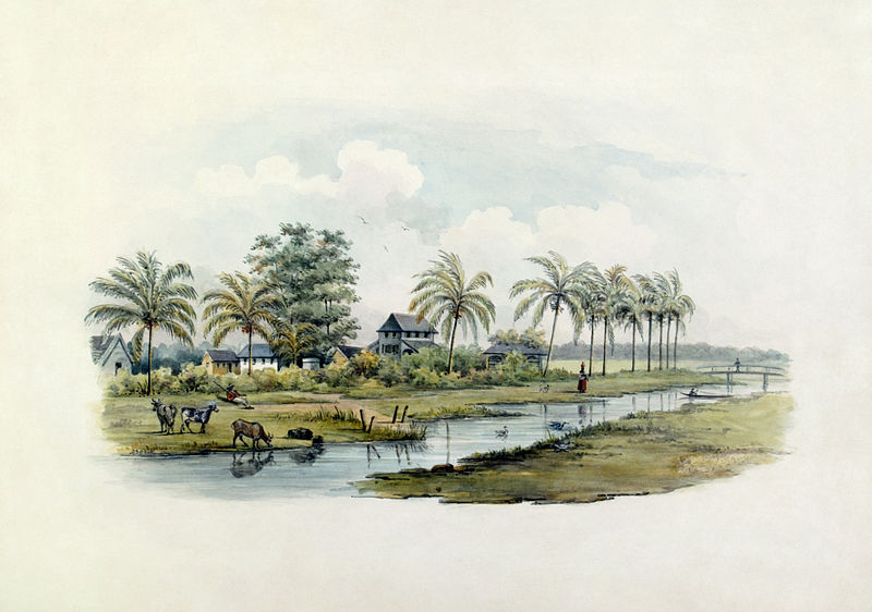
Afrikaans: Waterverf: Rivieruitsig met geboue van 'n katoenplantasie op die agtergrond. Die Moyplantasie van die Coronie-distrik van Suriname is aan 'n rivier geleë. Die uitsig is op die huise van die plantasiebewoners. Op die voorgrond is beeste wat suip, met 'n rustende veewagter wat met sy geweer oor hulle waak. Verder op stap 'n slavin met ware op haar kop, en 'n kano bevaar die water voor die voetgangerbrug.
Die distrik Coronie, vernoem na die Coronaspruit, het in 1851 'n onafhanklike distrik geword. Dit was die enigste distrik wat sy plantasies aan die seekus geplant het. Die eerstes is in 1808 deur die Engelse en Skotte gestig, en die name van die plantasies verwys steeds daarna. Die oudste plantasie is Burnside. Die belangrikste produkte was suiker en katoen, hoewel alle suikerplantasies geleidelik na katoenverbouing sou oorskakel.
English: Water colour. On the river is the Moy plantation, in the district of Coronie. The view in on the houses of the people living on the plantation. In the front animals are drinking, and to the right an overseer is resting with his gun. A female slave is walking with goods on her head. In the water is a korjaal.
The district of Coronie, named after the Corona creek, became an independent district in 1851. The first plantations were founded in 1808 by English and Scots, the names of the plantations still point to this. It was the only districts with plantations facing the sea coast. The most important products were sugar and cotton, although the sugar plantations would gradually make place for cotton. Riverside with buildings of a cotton plantation in the background.
Nederlands: Aquarel. Aan een rivier ligt de plantage Moy, uit het district Coronie. Het zicht is op de huizen van de bewoners van de plantage. Op de voorgrond staan dieren te drinken, en rechts ligt een opzichter met geweer te rusten. Verderop loopt een slavin met waar op haar hoofd. In het water ligt een korjaal.
Het district Coronie, vernoemd naar de Coronakreek, werd als district zelfstandig in 1851. Het was het enige district dat zijn plantages aan de zeekust legde. De eerste werden in 1808 aangelegd door Engelsen en Schotten, en de namen van de plantages verwijzen daar nog steeds naar. De oudste plantage is Burnside. De belangrijkste produkten waren suiker en katoen, hoewel gaandeweg alle suikerplantages zouden verdwijnen ten behoeve van de katoen. . Riviergezicht met gebouwen van een katoenplantage op de achtergrond |
||||||||||||||||||||||||||
| Fecha | entre 1860 y 1868 | ||||||||||||||||||||||||||
| Fuente |
|
||||||||||||||||||||||||||
| Autor | G.P.H. Zimmermann (Schilder). | ||||||||||||||||||||||||||
| Otras versiones | Fully restored version of File:Tropenmuseum Royal Tropical Institute Objectnumber 1138-7 Riviergezicht met gebouwen van een kato.jpg. See also File:Tropenmuseum Royal Tropical Institute Objectnumber 1138-7 Riviergezicht met gebouwen van een kato1.tif (partially restored version) and File:Tropenmuseum Royal Tropical Institute Objectnumber 1138-7 Riviergezicht met gebouwen van een kato2.tif (full restoration, uncompressed). | ||||||||||||||||||||||||||
Licencia
Este archivo ha sido donado a Wikimedia Commons por el Tropenmuseum dentro de un proyecto común. El Tropenmuseum, parte del Instituto Real para los Trópicos, proporciona exclusivamente imágenes hechas por su personal o libres de derechos de autor.
|
Este archivo se encuentra bajo la licencia Creative Commons Genérica de Atribución/Compartir-Igual 3.0.
Atribución: Collectie Wereldmuseum (v/h Tropenmuseum), part of the National Museum of World Cultures
- Eres libre:
- de compartir – de copiar, distribuir y transmitir el trabajo
- de remezclar – de adaptar el trabajo
- Bajo las siguientes condiciones:
- atribución – Debes otorgar el crédito correspondiente, proporcionar un enlace a la licencia e indicar si realizaste algún cambio. Puedes hacerlo de cualquier manera razonable pero no de manera que sugiera que el licenciante te respalda a ti o al uso que hagas del trabajo.
- compartir igual – En caso de mezclar, transformar o modificar este trabajo, deberás distribuir el trabajo resultante bajo la misma licencia o una compatible como el original.
Historial del archivo
Haz clic sobre una fecha y hora para ver el archivo tal como apareció en ese momento.
| Fecha y hora | Miniatura | Dimensiones | Usuario | Comentario | |
|---|---|---|---|---|---|
| actual | 06:05 11 nov 2009 | | 3550 × 2496 (3,75 MB) | Durova | == {{int:filedesc}} == {{Information |description={{en|1=Water colour. On the river is tha Moy plantation, in the district of Coronie. The view in on the houses of the people living on the plantation. In the front aminals are drinking, en to the right an |
Usos del archivo
Las siguientes páginas usan este archivo:
Uso global del archivo
Las wikis siguientes utilizan este archivo: